Featured Post

Tracking air pollution disparities -- daily -- from space

Studies have shown that pollution, whether from factories or traffic-snarled roads, disproportionately affects communities where economicall...

Saturday, February 27, 2021

Astra, Rocket Lab win launch contracts

WASHINGTON — Astra has won a NASA contract to launch a small constellation of Earth science cubesats, while General Atomics selected Rocket Lab for the launch of a small satellite with a NOAA hosted payload.


NASA announced Feb. 26 that it awarded a $7.95 million contract to Astra for three launches of the company’s Rocket 3 vehicle, which will be used to deploy the agency’s Time-Resolved Observations of Precipitation Structure and Storm Intensity with a Constellation of SmallSats (TROPICS) mission.


The three launches will take place over a 120-day period between Jan. 8 and July 31, 2022, from Kwajalein Atoll in the Marshall Islands. Those would be the first ground-based orbital launches from Kwajalein since the last Falcon 1 launch, from Omelek Island there, in 2009. Kwajalein has hosted several flights of the air-launched Pegasus rocket, most recently in 2012.


TROPICS is a constellation of six 3U cubesats in three orbital planes at an inclination of 30 degrees and altitude of 600 kilometers. Each identical satellite will carry a radiometer to collect profiles of temperature and water vapor as they pass over tropical weather systems. Scientists will use TROPICS to gain information on the structure of tropical storms, with the constellation allowing frequent revisits to study how those storms evolve.


The TROPICS contract is the second NASA award Astra has received. In December, the company was one of three small launch vehicle developers to win Venture Class Launch Services contracts for launches of cubesats. Astra’s award, valued at $3.9 million, is for the dedicated launch of 30 kilograms of cubesats to a 500-kilometer mid-inclination orbit, no later than June 2022.


General Atomics announced Feb. 24 that it selected Rocket Lab to launch an Orbital Test Bed satellite it developed carrying the Argos-4 Advanced Data Collection System (A-DCS) hosted payload. NOAA arranged for the launch of the payload through the Hosted Payload Solutions contract vehicle run by the Space Force’s Space and Missile Systems Center. The launch, on an Electron rocket, is scheduled for late 2021 or early 2022.


The A-DCS payload is part of the Argos data collection system that includes NOAA, the French space agency CNES, Eumetsat and the Indian space agency ISRO. The payload receives data from sensors, ranging from those mounted on ocean buoys to wildlife trackers, and relays that data to ground stations.


The contract is the second in as many weeks awarded by General Atomics for the launch of an Orbital Test Bed satellite. The company selected Firefly Aerospace Feb. 18 to launch a satellite carrying the Multi-Angle Imager for Aerosols hosted payload, a NASA Earth sciences instrument. That satellite will launch into polar orbit on an Alpha rocket from Vandenberg Air Force Base in California in 2022.


#Space | https://sciencespies.com/space/astra-rocket-lab-win-launch-contracts/

NASA deliberately made eerie glowing clouds... to study eerie glowing clouds

If you're in the right place at the right time, and you turn your eyes to the sky, you just might catch sight of something eerily beautiful: Wisps of cloud, high in the sky, glowing softly even though the Sun has already slipped below the horizon.


These are noctilucent, or night-shining, clouds, appearing at twilight primarily in the summer months, at high latitudes (but never observed from within the polar circle). They consist of collections of ice crystals high up in the atmosphere, at mesospheric altitudes between 76 and 85 kilometres (47 to 53 miles) above Earth's surface.


These wisps are too faint to be seen during the day, but after the Sun has sunk below the horizon, its last rays reach high into the atmosphere, even though the star itself is no longer visible from the planet's surface. There, these rays light up the clouds, causing them to glow against the darkening sky. For this reason, these glowing clouds are also known as polar mesospheric clouds.


They're extraordinarily beautiful – and also potentially very scientifically useful.


"What has attracted a lot of interest in these clouds is their sensitivity – they're occurring just on the edge of viability in the upper atmosphere, where it's incredibly dry and incredibly cold," said space physicist Richard Collins of the University of Alaska, Fairbanks.


"They're a very sensitive indicator of changes in the upper atmosphere – changes in temperature and/or changes in water vapour."


Collins and his team thought that these clouds might have something to do with the presence of water vapour in the upper atmosphere. So, they did the only sensible thing: They loaded a suborbital rocket with water and shot it into the sky above Alaska to see if they could make a noctilucent cloud.


In order to make sure they weren't mixing their artificial clouds with naturally occurring ones, they chose to launch the rocket into the winter pre-dawn sky, when conditions seem to be far less conducive to natural noctilucent cloud formation than in summer.


On 26 January 2018, the Super Soaker rocket mission launched, with one sounding rocket carrying 220-kilograms (485-pounds) of water in two canisters. Two other sounding rockets flew in accompaniment, carrying trimethyl aluminium (TMA) tracers to track wind movement.


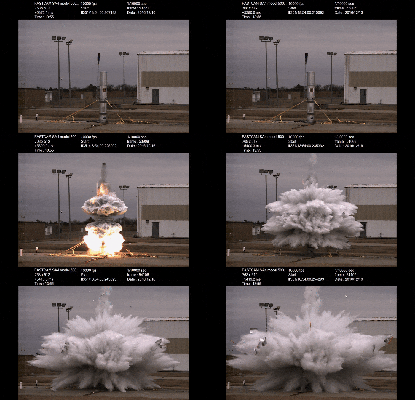
water releaseGround test of water release. (NASA's Wallops Flight Facility)


At an altitude of 85 kilometres, the water was released in a tremendous whoosh. Just 18 seconds later, a laser beam from a ground-based Rayleigh LIDAR detected a faint noctilucent cloud. Over three minutes, the cloud seemed to descend from a peak altitude of 92 kilometres (57 miles) down to 78 kilometres (48 miles).


To find out what happened and why the cloud forme, the team needed to get creative. Although they had atmospheric temperature measurements, they had no direct measurements of the temperature of the cloud, so they ran simulations of noctilucent cloud formation. The simulated conditions under which the cloud formed allowed the team to infer the change in temperature that must have taken place in the experiment.


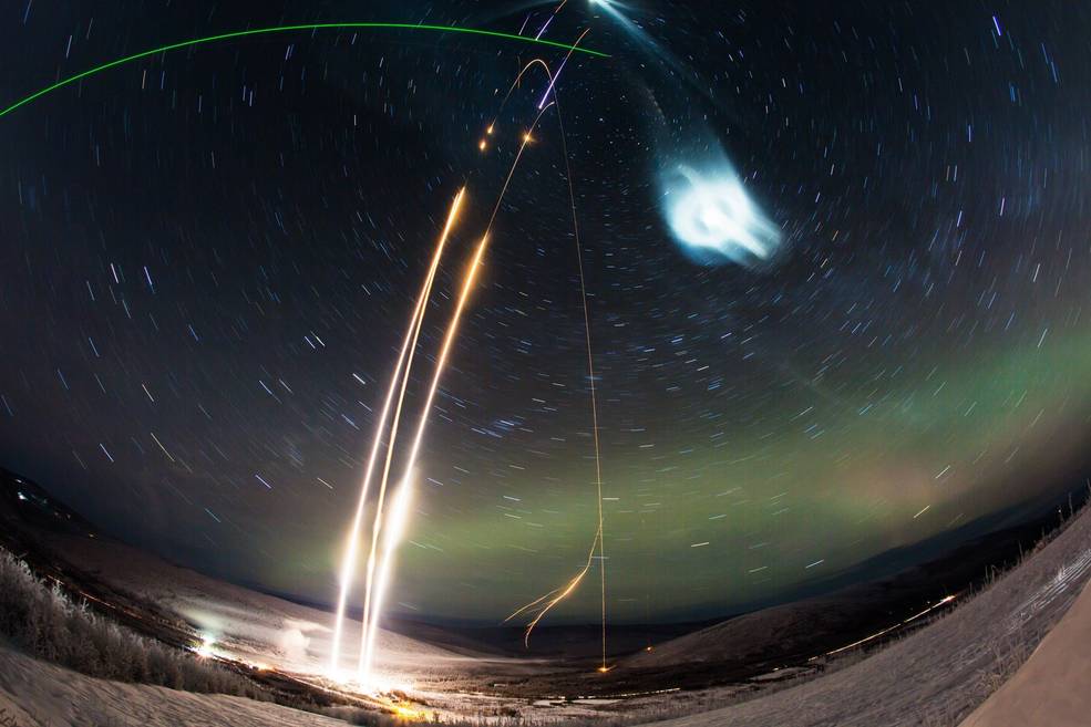
supersoaker launches timelapse(NASA's Wallops Flight Facility/Poker Flat Research Range/Zayn Roohi)


Above: Timelapse of the Super Soaker launch. The green laser beam visible at the top left is the LIDAR beam used to measure the artificial cloud.


The only way that the cloud formed was by a drop in temperature of about 25 degrees Celsius (45 degrees Fahrenheit). This suggested that the presence of the water vapour itself, released from the canisters, was responsible for that temperature drop. The increase in humidity also increased the temperature of the frost point, when water vapour condenses to ice crystals.


The combination of the drop in temperature and the rise in frost point allows the two temperatures to cross over, which in turn causes the water vapour to freeze into ice crystals.


"This is the first time anyone has experimentally demonstrated that polar mesospheric cloud formation in the mesosphere is directly linked to cooling by water vapour itself," said space physicist Irfan Azeem of aerospace company Astra, LLC.


This could explain, the researchers said, why noctilucent clouds seem to follow space launches. Water vapour is a common effluent in spacecraft exhaust, and scientists have observed the connection many times in the Arctic summer.


The polar mesosphere, in summer, has what the researchers call "persistent and vigorous" upwelling, which likely carries water vapour from lower altitudes and creates the same effect the team saw in their Super Soaker experiment.


"This might explain why the formation of mesospheric clouds by space traffic is more readily observed in the summer than in the winter," they wrote in their paper.


"Nonetheless, while space traffic water exhaust serves as a reservoir for mesospheric cloud production, this study suggests that the exhaust can also actively cool the mesosphere and induces the formation of mesospheric clouds, even in the polar winter."


So noctilucent-cloud-watchers could have a new way to predict when they're going to occur: by carefully following space launch schedules.


The team's research has been published in the Journal of Geophysical Research: Space Physics.


#Nature | https://sciencespies.com/nature/nasa-deliberately-made-eerie-glowing-clouds-to-study-eerie-glowing-clouds/

Oldest Known Wild Bird Hatches Chick at Age 70


On February 1, the world’s oldest known wild bird became a mother once again when her chick hatched on the Midway Atoll in the middle of the North Pacific Ocean.


Scientists first attached a red identifying ankle band to Wisdom, a Laysan albatross, in 1956. She’s now at least 70 years old and has outlived the researcher who first banded her, reports Nina Wu of the Honolulu Star Advertiser.


Just shy of 20 years ago, scientists thought the maximum age of the Laysan albatross was around 40 years, reports Kim Steutermann Rogers for National Geographic. But when Chandler Robbins, the U.S. Fish and Wildlife Service biologist who first banded her, recaptured the bird to replace the tattered ankle band in 2002, Wisdom was 51 and instantly vaulted into position as the oldest wild bird ever recorded.


In fact, Wisdom may be even older than 70. She was conservatively estimated to be five-years-old when scientists first recorded her vitals, but it hasn’t stopped her from laying eggs in eight out of the last 11 years, per National Geographic. The septuagenarian albatross has been raising chicks with her mate Akeakamai since at least 2010, according to the U.S. Fish and Wildlife Service (USFWS). Laysan albatross typically partner up for life, but Wisdom has had to find several new mates after she outlived her former beaus.


“We don’t know exactly how many chicks she’s raised, but certainly at least 35 based on what we know about her recent years performance,” Beth Flint, a biologist with the Marine National Monuments of the Pacific, tells Hawaii News Now.


When Wisdom and Akeakamai arrived at their nest site on Midway Atoll in late November, researchers like Flint were excited and relieved. “Each year that Wisdom returns, we learn more about how long seabirds can live and raise chicks,” Flint tells the Honolulu Star Advertiser.


To get their new chick strong enough to head out to sea by summertime, Wisdom and Akeakamai will take turns at the nest while the other uses their seven-foot wingspan to traverse the ocean in search of food to bring back and regurgitate for the chick.


In Hawaii, Wisdom’s significance also goes beyond her advanced age. Indigenous Hawaiian culture associates the Laysan albatross, or mōlī, with the god of rain and agriculture, Lono, according to National Geographic.


Midway, two tiny islands that once housed a World War II military base, is the nesting site for nearly three-quarters of the world’s Laysan albatrosses as well as 40 percent of black-footed albatrosses and some 20 other bird species. But this vital habitat is threatened by climate change-driven sea level rise while the albatross themselves are being killed by plastic pollution and, since 2015, a scourge of invasive house mice, per the USFWS.


Not normally considered dangerous predators, the mice were actually killing some of the albatross, which are so dedicated to their eggs that they scarcely move even as they’re being eaten alive by mice.


Because albatross only lay one egg each year, every individual chick makes a significant contribution to growing the population, making Wisdom a rockstar for her species.


Flint says Wisdom’s annual arrival and growing notoriety has also made her a valuable symbol for conservation.


“Her return not only inspires bird lovers everywhere, but helps us better understand how we can protect these graceful seabirds and the habitat they need to survive into the future,” she tells the Star Advertiser.


#News | https://sciencespies.com/news/oldest-known-wild-bird-hatches-chick-at-age-70/

Nicole Robinson named president of Ursa Space Systems

SAN FRANCISCO – After 14 years at satellite communications fleet operator SES, Nicole Robinson is taking on a new role: president of Ursa Space Systems, a geospatial analytics firm based in Ithaca, New York.


Robinson was SES senior vice president of global government when she began talking in 2020 with Adam Maher, Ursa Space CEO and co-founder.


“I did my homework to understand synthetic aperture radar (SAR), Earth-observation and the role Ursa was playing in the market,” Robinson told SpaceNews. “The more I learned, the more I thought, ‘There’s something I can bring to this team that can help take them to the next level.’”


Ursa Space, founded in 2014, acquires imagery and data from SAR satellite operators around the world, which it fuses them with other types of data to answer questions for government and commercial customers. The company is well known, for example, for monitoring crude oil storage around the world.


With Robinson’s support, Ursa “plans to expand its product offerings for both commercial and government customers,” according to the company’s Feb. 26 news release.


Although Robinson was not eager to leave SES, which she said felt like home, she has been intrigued by space industry startups since SES purchased O3b in 2016.


“The energy that came from this 100-person [O3b] team imprinted on the DNA of SES, which had been operating a certain way for decades,” Robinson said. “That energy, thought leadership and pushing the envelope was something that I wanted more of.”


Robinson is joining Ursa during an unusually busy year for SAR. Companies around the world are establishing or expanding their SAR satellite fleets.


“I think there will be upwards of 40 SAR satellites by the end of 2021, about double what we had last year,” Robinson said. “Ursa will be retrieving all of that information into our platform.”


#Space | https://sciencespies.com/space/nicole-robinson-named-president-of-ursa-space-systems/

Dust from asteroid that ended dinosaur reign closes case on impact extinction theory


Having dominated the planet's surface for hundreds of millions of years, dinosaur diversity came to a dramatic conclusion some 66 million years ago at the hot end of an asteroid impact with what is today Mexico's Yucatán Peninsula.


It's a theory so swollen with data that it's hard to imagine any room for doubt remains that this is indeed what happened. Were it a cold case, it'd be rubber-stamped and filed under 'Solved' by now.


But scientists are a nitpicky bunch, and a tiny gap in the chain of evidence linking signs of a global apocalypse with the scene of the crime has been begging to be closed.


An international team of researchers collaborating on a study of material from the Yucatán Peninsula's famous Chicxulub impact crater has finally matched the chemical signature of meteoritic dust within its rock with that of the geological boundary representing the dinosaur extinction event.


It appears to be a clear sign that the thin blanket of dust deposited on Earth's crust 66 million years ago originated from an impact event at this very spot.


"We are now at the level of coincidence that geologically doesn't happen without causation," says geoscientist Sean Gulick from the University of Texas in the US.


Together with fellow geoscientist Joanna Morgan from Imperial College London, Gulick led an expedition in 2016 to retrieve a sample of shattered rock from more than half a kilometre into the crater's peak ring.


Four different laboratories carried out measurements on the sample. The results not only help unite a major transition in the fossil record with the site, they also hint at a timeline that supports a rapid drop in dinosaur populations over as little as a decade or two.


"If you're actually going to put a clock on extinction 66 million years ago, you could easily make an argument that it all happened within a couple of decades, which is basically how long it takes for everything to starve to death," says Gulick.


Half a century ago, the question of why the diversity of fossils representing the Mesozoic era came to such an abrupt end in the geological record was an open one. Whatever was responsible for the sudden loss of 75 percent of life on Earth, it had to be relatively quick, and global.


Hypotheses of such cataclysmic violence were mostly centred on two possibilities – one emerging from underground as a surge of volcanic activity, the other from above in the form of a comet or asteroid strike radically disrupting global climate.


In 1980, American physicist Luis Alvarez and his son, a geologist named Walter, published a study on a thin layer of sediment dividing the dinosaur-populated Cretaceous period from the post-dinosaur world of the Palaeogene.


A defining characteristic of this millimetre- to centimetre-thick thin strip of sedimentary rock was an unusually high amount of the element iridium, a metal that isn't found in abundance in Earth's crust.


One place you will find plenty of iridium is in meteorites. So Alvarez and son's discovery marked the first solid piece of evidence that something from space splattered its remains all over the planet at the time dinosaur biodiversity took a dive.


Coincidentally, the site of that colossal collision was the focus of ongoing research around the same time, though making a clear connection between the 180- to 200-kilometre-long (112- to 125-mile) scar at the southern edge of the Gulf of Mexico with the killer asteroid wouldn't happen until the 1990s.


Since then, evidence in support of an asteroid impact has only grown stronger, with models going so far as to suggest the angle, as well as the location of the Chicxulub impact, played crucial roles in the magnitude of the extinction event.


Signs that a zone of intense geological activity in western India called the Deccan Traps was contributing vast amounts of greenhouse gases at the time meant the volcano hypothesis has never been entirely ruled out, at least as a possible contributing factor.


Whether this tectonic hotspot played any role in the famous extinction event, or even helped biodiversity recover from it after, is still up for debate.


What is no longer a point of serious discussion is whether the 12-kilometre-wide chunk of rock that struck off the coast of what is now Mexico roughly 66 million years ago is the same one that dusted the remains of countless dinosaurs.


"The circle is now finally complete," says study leader Steven Goderis, a geochemist from the Vrije Universiteit Brussel in Belgium.


Case closed.


This research was published in Science Advances.


#Nature | https://sciencespies.com/nature/dust-from-asteroid-that-ended-dinosaur-reign-closes-case-on-impact-extinction-theory/

Automaker Geely gains approval for satellites for self-driving constellation

HELSINKI — Chinese private automaker Geely has got the green light to begin manufacturing satellites for navigation, connectivity and communications needed for self-driving cars.


China’s National Development and Reform Commission (NDRC) approved a license for a new facility Taizhou, Zhejiang province, in which Geely is based, to begin manufacturing earlier in February.


Geely announced plans for the $326 million Taizhou project in March last year and now plans to begin production in October. The facility will have an estimated production output of over 500 satellites per year, according to a press release.


The satellite constellation will provide Vehicle-to-vehicle (V2V) and Vehicle-to X-(V2X) communications to realize full autonomous self-driving. 


Geely has not released a figure for the total planned number of satellites it aims to launch, but the production capacity suggests thousands. Geely says the constellation will not need costly base stations to realise self-driving. 


Geely is planning to launch two demonstration satellites in the first half of this year with the goal of testing navigation enhancement. While GPS, Beidou and other GNSS satellite systems provide positioning accuracy to the level of meters, navigation enhancement to the centimeter level is required for driverless vehicles. 


The pair of 130-kilogram satellites were understood to have been transported to the Jiuquan Satellite Launch Center in June 2020. It is possible launch has been delayed by launch failures of commercial Kuaizhou rockets shortly after.


Geely’s plans are understood to involve combining navigation enhancement and connectivity to create a smart, comprehensive “mobility ecosystem”.


Geely has recently been branching out into trucking, rail, drones and developing deeper cooperation with Volvo while also looking towards low Earth orbit.


Commercial space expansion


Geely’s move follows a number of government decisions going back to late 2014 to allow private capital into the formerly closed-off space sector.


Hundreds of firms focusing on launch vehicles, satellite manufacture, ground stations and downstream applications have since sprung up. 


China’s Geely Technology Group states it saw the NDRC decision to add “satellite internet” to a list of “new infrastructures” in April 2020 as an opportunity to establish an industrial chain including research and development, design, manufacturing, launch and market application for its own satellite network.


A subsidiary of Geely, Zhejiang Shikong Daoyu Tech Co, has also undertaken a satellite $637 million satellite internet-related project in Qingdao, Shandong province. 


Xu Zhihao, CEO of Geely Technology Group, said that satellite manufacturing is crucial for the entire satellite industry chain and the Taizhou facility will meet the development needs of this rapidly developing industry, including shortening development cycles of micro-satellites, faster technology updates, and more functionality. 


Geely’s plans could provide lucrative opportunities for emerging commercial launch providers if they can get to the pad and prove reliability, boosting Chinese government objectives of creating a commercial space ecosystem and new supply chains.


State-owned spinoffs China Rocket Co. Ltd., Expace and CAS Space and nominally private companies Galactic Energy, iSpace, OneSpace, Deep Blue Aerospace and Landspace are planning launches this year.


Chinese megaconstellations


Geely is far from the only entrant into LEO constellations in China. Giant state-owned space and defense contractors China Aerospace Science and Technology Corp. (CASC) and China Aerospace Science and Industry Corp. (CASIC) also have plans for constellations of large numbers of low Earth orbit satellites, namely the Hongyan (CASC) and Honyun and Xingyun (CASIC) constellations.


These variously aim at providing coverage in remote areas, maritime and aviation connectivity, and Internet and Things and backhauling services.


Additionally a spectrum application has been filed with the International Telecommunication Union (ITU) for a constellation named “GW”. The mystery constellation would consist of nearly 13,000 satellites and is understood to have state-owned satellite and telecommunications entities as the planned operators. Galaxy Space, a private company, also plans a 5G LEO constellation.


#Space | https://sciencespies.com/space/automaker-geely-gains-approval-for-satellites-for-self-driving-constellation/

Mega iceberg about the size of Los Angeles just broke off from an Antarctic ice shelf

A giant iceberg, more than 20 times the size of Manhattan, just split off from Antarctica's Brunt Ice Shelf. This dramatic breakup comes after a major crack formed on the shelf in November 2020 and continued to grow until the 'berg finally broke off Friday morning (Feb. 26).


The so-called "North Rift" crack is the third major chasm to actively tear across the Brunt Ice Shelf in the last decade, and so scientists with the British Antarctic Survey (BAS) were absolutely expecting the split.


"Our teams at BAS have been prepared for the calving of an iceberg from Brunt Ice Shelf for years," Dame Jane Francis, the director of the BAS, said in a statement.


"Over [the] coming weeks or months, the iceberg may move away; or it could run aground and remain close to Brunt Ice Shelf."


(Icebergs are pieces of ice that have broken off from glaciers or ice shelves and are now floating in open water, according to the National Oceanic and Atmospheric Administration.)


Related: Photos: diving beneath Antarctica's Ross Ice Shelf


The North Rift crack grew toward the northeast at a rate of about 0.6 miles (1 km) per day in January; but on the morning of Feb. 26, the crack widened a couple hundred meters in just hours.


This ice split happened due to a natural process, and there's no evidence that climate change played a role, according to the statement. The Brunt Ice Shelf, a 492-foot-thick (150 meters) slab of ice, flows west at 1.2 miles (2 km) per year and routinely calves icebergs.


This iceberg, however, happened to be very big, with an estimated size of about 490 square miles (1,270 square km).


"Although the breaking off of large parts of Antarctic ice shelves is an entirely normal part of how they work, large calving events such as the one detected at the Brunt Ice Shelf on Friday remain quite rare and exciting," Adrian Luckman, a professor at Swansea University in Wales who was tracking the shelf through satellite images in the last few weeks, told the BBC.


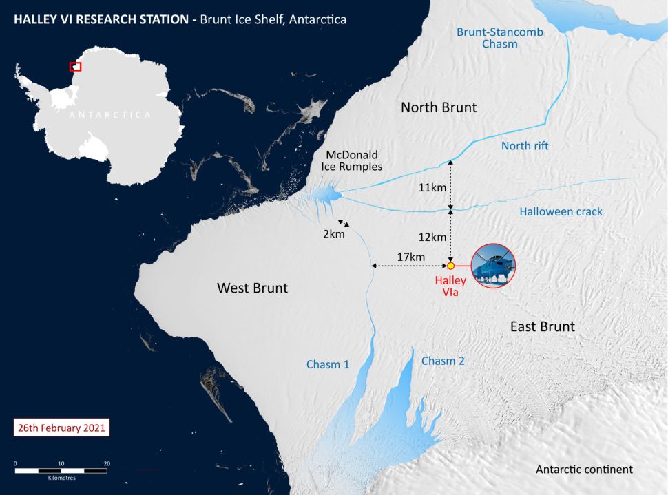
76ugRxT3hGKgpoz6mqiJWh 970 80A map shows the Halley VI research station in relation to the north rift crack. (Image credit: British Antarctic Survey)


The Brunt Ice Shelf is home to the BAS Halley VI research station, where scientists observe atmospheric and space weather; but the station will likely not be affected by this splitting, according to the statement.


Related: Photos: Behind the scenes of an Antarctic research base's relocation


In 2016, the BAS relocated the station 20 miles (32 km) inland to avoid the two other major cracks in the ice shelf known as "Chasm 1" and the "Halloween Crack," both of which haven't widened any further in the past 18 months, according to the statement.


The research station is now closed for winter, and the 12-person team left Antarctica earlier in February.


Because of the unpredictability of iceberg calving, and the difficulty of evacuating during the dark and frigid winters, the research team has been working at the station only during the Antarctic summer over the past four years. 


More than a dozen GPS monitors measure and relay information about ice deformation of the shelf back to the team in the U.K. every day. The researchers also use satellite images from the European Space Agency, NASA, and the German satellite TerraSAR-X to monitor the ice.


"Our job now is to keep a close eye on the situation and assess any potential impact of the present calving on the remaining ice shelf," Simon Garrod, the BAS director of operations, said in the statement.


Related content:


50 amazing facts about Antarctica


Life on the edge: photos from drilling the ross Ice Shelf


In photos: Antarctica's larsen C ice shelf through time


This article was originally published by Live Science. Read the original article here.


#Environment | https://sciencespies.com/environment/mega-iceberg-about-the-size-of-los-angeles-just-broke-off-from-an-antarctic-ice-shelf/