Featured Post

Tracking air pollution disparities -- daily -- from space

Studies have shown that pollution, whether from factories or traffic-snarled roads, disproportionately affects communities where economicall...

Monday, January 31, 2022

Planet Earth contains over 9,000 tree species yet to be discovered, scientists say

An ambitious, first-of-its-kind effort to estimate how many different kinds of trees exist on Earth suggests our planet is teeming with thousands of tree species that still haven't been discovered.


The huge international research effort – involving the work of over 100 scientists – estimates that there are approximately 73,000 tree species in total on Earth, yet so far we've only documented about 64,000 of these.

The remainder, researchers say, equates to roughly 9,200 undiscovered tree species that so far have eluded scientific attention and study.

"We combined individual datasets into one massive global dataset of tree-level data," says quantitative forest ecologist Jingjing Liang of Purdue University from Purdue University.

"Each set comes from someone going out to a forest stand and measuring every single tree – collecting information about the tree species, sizes, and other characteristics. Counting the number of tree species worldwide is like a puzzle with pieces spread all over the world."

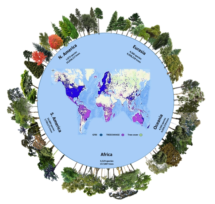
""Tree species and individuals per continent in the GFBI database. (Gatti et al., PNAS, 2022)

In this case, the puzzle consisted of combining two vast tree datasets – one belonging to the Global Forest Biodiversity Initiative, of which Liang is the coordinator, and another database called TreeChange.

The data-pooling project, combining many years' worth of ground-sourced tree cataloguing, compiled a global occurrence dataset of tree species across a grid of over nine thousand 100 × 100-kilometer (62 x 62-mile) cells on the planet.


With statistical adjustments accounting for the comparative richness of biomes in different regions, the researchers inferred that there are likely about 9,200 tree species yet to be discovered, although they fully acknowledge this is an estimate based on incomplete data, including areas where the mapping and analysis of tree species is limited.

Nonetheless, the analysis delivers important new insights on the distribution and occurrence of trees around the world.

"Our estimates at continental scales show that roughly 43 percent of all Earth's tree species occur in South America, followed by Eurasia (22 percent), Africa (16 percent), North America (15 percent), and Oceania (11 percent)," the researchers write in their new study.

"More undiscovered species likely occur in South America than any other continent."

The South American species not yet discovered are thought to constitute about 40 percent of all undiscovered species. South America also contains the highest number of rare species (about 8,200 species), and the highest percentage (49 percent) of endemic species not found on other continents.

"Beyond the 27,000 known tree species in South America, there might be as many as another 4,000 species yet to be discovered there," says forest ecologist Peter Reich from the University of Michigan.


"This makes forest conservation of paramount priority in South America, especially considering the current tropical forest crisis from anthropogenic impacts such as deforestation, fires and climate change."

In recent years, that crisis has come into painfully clearer focus, and the researchers say it's imperative that we identify the true diversity of tree life as soon as possible, so as to be able to better shield these threatened species from the changes imperiling them.

"This new global dataset is a significant piece of the puzzle in ecology and biodiversity," says forest researcher Andy Marshall from the University of the Sunshine Coast in Australia.

"The better the information, the better we can inform national and international plans for conservation priorities and biodiversity targets and management – potentially saving endangered tree species in the process."

The findings are reported in PNAS.


#Nature | https://sciencespies.com/nature/planet-earth-contains-over-9000-tree-species-yet-to-be-discovered-scientists-say/

Falcon 9 launches Italian radar satellite

WASHINGTON — A SpaceX Falcon 9 placed an Italian radar mapping satellite into orbit Jan. 31 after four days of delays caused by range and weather problems.


The Falcon 9 lifted off from Space Launch Complex 40 at Cape Canaveral Space Force Station in Florida at 6:11 p.m. Eastern. The rocket’s upper stage deployed its payload, the Cosmo-SkyMed Second Generation (CSG) 2 satellite for the Italian space agency ASI and the Italian military, an hour after liftoff.


The rocket’s first stage made a landing back at Landing Zone 1 at Cape Canaveral eight minutes after liftoff. The booster was originally built as a side booster for the triple-core Falcon Heavy rocket and flew on the second and third Falcon Heavy missions in 2019. This was the first launch where a Falcon Heavy side booster had been converted into a Falcon 9 booster.


The launch was originally scheduled for Jan. 27 but was scrubbed by poor weather, which also postponed launch attempts the next two days. Weather cooperated for a fourth attempt Jan. 30, but a cruise ship sailed into restricted waters off the Florida coast and could not move out of the way in time for the launch.


The 2,200-kilogram satellite, built by Thales Alenia Space, is the second in a fleet of four satellites intended to replace the original Cosmo-SkyMed satellites launched between 2007 and 2010. The second-generation satellites provide X-band synthetic aperture radar imagery, like the first-generation satellites, but can also collect images of two regions hundreds of kilometers apart simultaneously.


CSG-2 was originally slated to launch on a Vega C. However, with the first launch of that vehicle delayed until at least May, ASI elected last fall to move the launch to a Falcon 9 in the hopes of launching the spacecraft by the end of the year, a decision that raised eyebrows among some in the in the European space industry.


“Since Arianespace backlog was already full on Soyuz and Ariane systems in 2021, it was not possible to have a European back-up solution compliant with the CSG-2 schedule,” ASI said in a statement last fall justifying its decision to acquire a launch from SpaceX. “In line with its long-lasting support ensured to the European launch industry, ASI confirmed its trust in Arianespace and Vega C capabilities by contracting the launch of the CSG-3 satellite, planned for 2024.”


High launch cadence


The launch is the fourth Falcon 9 mission of 2022, after two Starlink launches Jan. 6 and Jan. 18 and the Transporter-3 rideshare mission Jan. 13. Another Falcon 9 launch of Starlink satellites is scheduled for no earlier than Feb. 1 from the Kennedy Space Center, while a Falcon 9 will launch a classified payload for the National Reconnaissance Office from Vandenberg Space Force Base in California Feb. 2.


While SpaceX executives have not disclosed a specific forecast of the number of launches scheduled for this year, Sandy Magnus, a member of NASA’s Aerospace Safety Advisory Panel, said at a meeting of the committee Jan. 27 that the company was planning for 52 launches in 2022, or one per week.


“That’s an incredible pace,” she said, but injected a note of caution. “NASA and SpaceX will have to ensure the appropriate attention and priority is focused on NASA missions and the right resources are brought to bear to maintain that pace at a safe measure.”


However, SpaceX has struggled to maintain a high launch cadence in the past. In 2021, the company performed 20 launches in the first six months, but then only three in the next four months, in part because of delays in the development of Starlink satellites that constitute the majority of the Falcon 9 manifest.


SpaceX did pick up the pace in the final two months of the year, including three launches within 72 hours in December. It finished the year with 31 launches, a record for the company.


That pace will be governed both by the availability of payloads as well as the ability of SpaceX to refurbish Falcon 9 first stages and build new upper stages. In a podcast in December, SpaceX Chief Executive Elon Musk suggested his company’s current pace of refurbishment was falling short of his goals. “The booster is not as rapidly and completely reusable as we’d like, and nor are the fairings,” he said.


In the same podcast, he offered an estimate of the cost of a Falcon 9 launch. “Our minimum marginal cost, not counting overhead, per flight is on the order of $15–20 million,” he said, with the bulk of that cost going to the upper stage, which he estimated at $10 million.


“That’s extremely good. It’s by far better than any rocket ever in history,” he said, but that the full reusability promised by SpaceX’s next-generation Starship vehicle will significantly reduce that cost while increasing payload capacity. “Starship, in theory, could do a cost per launch of a million, two million dollars, or something like that, and put over 100 tons into orbit. This is crazy.”


#Space | https://sciencespies.com/space/falcon-9-launches-italian-radar-satellite/

Some Finnish forest owners do not believe in biodiversity loss – for others it is a crisis

We should start talking about biodiversity loss denial, just like we discussed climate change denial in the recent past, researchers from the University of Eastern Finland and the University of Helsinki say.


Numerous surveys of forest owners have found that private family forest owners in Finland value nature and biodiversity. However, such findings tell us more about the general ideals of Western culture than about forest owners as protectors of biodiversity.


A study of forest owners conducted by the University of Eastern Finland's School of Forest Sciences and Department of Geographical and Historical Studies along with the University of Helsinki's Department of Forest Sciences identified three common modes of thought that forest owners use to conceptualise maintenance of biodiversity and their own role in that process. These modes of thought also reflect different ideas about sustainable forest use among family forest owners, who hold control over the use of two thirds of Finland's forests.


Just under 40 per cent of forest owners fall back on a mode of thought which calls for them to do no more to promote biodiversity than the law requires. They may agree to management measures recommended for their commercial forests by forestry professionals to appease them, but they do not perceive a genuine need for these measures.


"To this group, the problem of biodiversity loss doesn't exist, and concerns about the environment are seen as unrealistic fringe ideas held by nature conservationists. Modern ideas about sustainability are not part of this mode of thought," explains Tuomo Takala, a researcher at the University of Eastern Finland.


For the next 40 per cent of forest owners, the standard measures for taking biodiversity into account in cutting operations, such as a buffer zone on the shoreline or a group of retention trees left in a clear-cut area, leave a positive feeling that they have done their part to conserve biodiversity. Habitats of endangered species can also be saved in cutting operations without any opposition as long as these habitats are known beforehand and are not too large or many.


"To this group, finding existing areas of high nature value and preserving them in an economically optimal way is precisely what is meant by conservation of biodiversity. Thanks to the best forestry in the world, there cannot be such a thing as biodiversity loss here," Takala elaborates.


In practice, these forest owners prefer to leave responsibility for conserving biodiversity to the forestry professionals planning the cuttings. This multi-objective forestry outlook is also the mainstream view of sustainable forestry in Finnish forest policy.


"We can think of it as a weak-sustainability model that approaches the different dimensions of sustainability equally in principle, but in which commercial forest use ultimately sets the framework that conservation efforts operate within."


The two modes of thought above illustrate two ways in which forest owners keep the unpleasant idea of biodiversity loss out of their sight, even if biodiversity loss in Finnish forests is well documented and frequently raised in the media. These and other manifestations of biodiversity loss denial, should be discussed more -- just like climate change denial was discussed in the recent past.


Biodiversity loss is only a reality for a fifth of forest owners


One in five forest owners views the loss of biodiversity as an emergency.


"According to this mode of thought, we are quickly destroying our forest nature," Takala explains.


"According to this group, the way we use forests needs to be changed fundamentally and quickly, either voluntarily or through further regulation. Especially old-growth forests need to be removed from commercial forestry use in significant numbers. Specific sites of high nature value and areas where endangered species currently exist aren't the only things worth preserving -- some sites where endangered species could settle in the coming decades should also be saved."


Considering the needs of nature gives concerned forest owners a framework within which they can plan their commercial forest use in a way that prioritises the ecological dimension of sustainability over the commercial dimension. These forest owners take the responsibility of conserving biodiversity into their own hands. They do not outsource it to the forestry professionals who plan their cuttings, knowing that conserving biodiversity is not the primary task of these professionals.


"In this strong-sustainability mode of thought, the most impactful decisions from the biodiversity perspective have already been made before any forestry professionals enter the picture."


All the aforementioned modes of thought naturally include the conviction that they are the correct way of looking at the situation. It is important to notice that individuals cannot simply jump from one mode of thought to another at a whim.


Paying more attention to environmental concern and sensitivity


The modes of thought discussed above pervade all discussion on the environmental effects of forestry. When, for example, the EU's taxonomy, rooted in a strong-sustainability mode of thought, meets the weak-sustainability mode of thought prevalent in mainstream Finnish forest policy, conflict is inevitable. Some are in a state of emergency, while others see no problem at all.


"To understand and manage the conflicts and the polarised conversation, it's essential that we learn how to separate these two ways of conceptualising sustainability in forest use. The idea of one sustainability -- a single goal shared by everyone -- obscures our fundamental differences of conception, narrows political discussion and hamstrings our attempts to make considered decisions," Takala explains.


Understanding this difference is particularly important for those making decisions about forest use. By asking whether we and our forests are in a state of environmental emergency, and whether we need to fundamentally change how we use forests as a result, is a good way of examining our differing conceptions of sustainability.


"At the simplest level, this is about the different values and levels of environmental sensitivity people have. Too often, we still think of conflicts regarding forests and the solutions to those conflicts as simple informational challenges," the project's researchers note.


Where to start with strong-sustainability forest services?


The study found that interest in new forest services that concentrate on nature is surprisingly common among forest owners -- far more common than concern over biodiversity loss. If we want to promote strong-sustainability thinking among forest owners, we should emphasise service products that allow forest owners to examine nature in their own forests and work together with nature professionals to plan their forest use with the needs of nature as the starting point.


Additionally, it is high time to develop new forest planning and advisory services in which commercial forest use is planned in the framework of biodiversity maintenance instead of the other way around and to offer these services alongside current forestry planning and advisory products. Such strong-sustainability forest services are currently not available in Finland.


"The personal experiences produced by forest services could be an effective way of increasing people's sensitivity to environmental issues. Of course, they would also give forest owners more information about nature and their own values, but information alone is not enough -- information about biodiversity loss is already out there for anyone to find, as long as they're prepared to take it in."


"The most important thing a strong-sustainability forest service model can achieve is getting forest owners to ask themselves what they can and are ready to do for nature."


The study was funded by the Maj and Tor Nessling Foundation.


#Nature | https://sciencespies.com/nature/some-finnish-forest-owners-do-not-believe-in-biodiversity-loss-for-others-it-is-a-crisis/

Number of Earth's tree species estimated to be 14% higher than currently known, with some 9,200 species yet to be discovered

A new study involving more than 100 scientists from across the globe and the largest forest database yet assembled estimates that there are about 73,000 tree species on Earth, including about 9,200 species yet to be discovered.


The global estimate is about 14% higher than the current number of known tree species. Most of the undiscovered species are likely to be rare, with very low populations and limited spatial distribution, the study shows.


That makes the undiscovered species especially vulnerable to human-caused disruptions such as deforestation and climate change, according to the study authors, who say the new findings will help prioritize forest conservation efforts.


"These results highlight the vulnerability of global forest biodiversity to anthropogenic changes, particularly land use and climate, because the survival of rare taxa is disproportionately threatened by these pressures," said University of Michigan forest ecologist Peter Reich, one of two senior authors of a paper scheduled for publication Jan. 31 in Proceedings of the National Academy of Sciences.


"By establishing a quantitative benchmark, this study could contribute to tree and forest conservation efforts and the future discovery of new trees and associated species in certain parts of the world," said Reich, director of the Institute for Global Change Biology at U-M's School for Environment and Sustainability.


For the study, the researchers combined tree abundance and occurrence data from two global datasets -- one from the Global Forest Biodiversity Initiative and the other from TREECHANGE -- that use ground-sourced forest-plot data. The combined databases yielded a total of 64,100 documented tree species worldwide, a total similar to a previous study that found about 60,000 tree species on the planet.


"We combined individual datasets into one massive global dataset of tree-level data," said the study's other senior author, Jingjing Liang of Purdue University, coordinator of the Global Forest Biodiversity Initiative.


"Each set comes from someone going out to a forest stand and measuring every single tree -- collecting information about the tree species, sizes and other characteristics. Counting the number of tree species worldwide is like a puzzle with pieces spread all over the world."


After combining the datasets, the researchers used novel statistical methods to estimate the total number of unique tree species at biome, continental and global scales -- including species yet to be discovered and described by scientists. A biome is a major ecological community type, such as a tropical rainforest, a boreal forest or a savanna.


Their conservative estimate of the total number of tree species on Earth is 73,274, which means there are likely about 9,200 tree species yet to be discovered, according to the researchers, who say their new study uses a vastly more extensive dataset and more advanced statistical methods than previous attempts to estimate the planet's tree diversity. The researchers used modern developments of techniques first devised by mathematician Alan Turing during World War II to crack Nazi code, Reich said.


Roughly 40% of the undiscovered tree species -- more than on any other continent -- are likely to be in South America, which is mentioned repeatedly in the study as being of special significance for global tree diversity.


South America is also the continent with the highest estimated number of rare tree species (about 8,200) and the highest estimated percentage (49%) of continentally endemic tree species -- meaning species found only on that continent.


Hot spots of undiscovered South American tree species likely include the tropical and subtropical moist forests of the Amazon basin, as well as Andean forests at elevations between 1,000 meters (about 3,300 feet) and 3,500 meters (about 11,480 feet).


"Beyond the 27,000 known tree species in South America, there might be as many as another 4,000 species yet to be discovered there. Most of them could be endemic and located in diversity hot spots of the Amazon basin and the Andes-Amazon interface," said Reich, who was recruited by U-M's Biosciences Initiative and joined the faculty last fall from the University of Minnesota, where he maintains a dual appointment.


"This makes forest conservation of paramount priority in South America, especially considering the current tropical forest crisis from anthropogenic impacts such as deforestation, fires and climate change," he said.


Worldwide, roughly half to two-thirds of all already known tree species occur in tropical and subtropical moist forests, which are both species-rich and poorly studied by scientists. Tropical and subtropical dry forests likely hold high numbers of undiscovered tree species, as well.


"Extensive knowledge of tree richness and diversity is key to preserving the stability and functioning of ecosystems," said study lead author Roberto Cazzolla Gatti of the University of Bologna in Italy.


Forests provide many "ecosystem services" to humanity for free. In addition to supplying timber, fuelwood, fiber and other products, forests clean the air, filter the water, and help control erosion and flooding. They help preserve biodiversity, store climate-warming carbon, and promote soil formation and nutrient cycling while offering recreational opportunities such as hiking, camping, fishing and hunting.


#Nature | https://sciencespies.com/nature/number-of-earths-tree-species-estimated-to-be-14-higher-than-currently-known-with-some-9200-species-yet-to-be-discovered/

Being a super-friendly dog has one potential drawback, study finds

The friendliness of your dog could have serious implications for its social standing with other canines, new research suggests.

In a questionnaire designed to measure the personality traits of companion dogs and compare them against their social ranking with other canines in multi-dog families, researchers found that dogs who scored highly for agreeableness and affection were less likely to have a dominant status in the group hierarchy.


By contrast, dogs who scored highly on other measures in the Canine Big Five personality traits – specifically extraversion, openness, and conscientiousness – were more likely to be the dominant animals in their social group. The final trait, neuroticism, appeared to show no link with dominance in the dog hierarchy.

"Our aim was to find what traits might be related to the formation of these hierarchies and the rank of the individuals," explains a team led by biologist Kata Vékony, the first author of the study, from Eötvös Loránd University in Hungary.

The findings, based on questionnaire responses from 615 dog owners from around the world (each of whom owned at least two companion dogs), suggest that a dog's age is also related to its hierarchical social status – with older dogs generally scoring higher dominance scores.

According to the researchers, that result – which has previously been shown in other studies of dog hierarchies too – can at least partially be explained by the fact that the older dogs in this analysis tended to be less agreeable and affectionate.


In other words: older dogs were generally more dominant but at the same time weren't highly agreeable, whereas highly agreeable (and generally younger) dogs weren't likely to be the dominant dog in their families.

In the wild, where animals have to compete amongst one another for limited resources, achieving dominance over other animals in a social group can have important implications for survival.

In the more comfortable, catered-to existence of companion dogs, the same sorts of social ranking system among animals still applies, but the consequences of a low ranking aren't quite so severe.

"Once stabilized, hierarchy can help the access to these resources – in favor of the dominant individuals – without serious conflict or harm," the researchers write in the paper.

"In groups of co-habiting companion dogs however, competition for these resources is less prevalent as they are readily provided and distributed by the owner."

But even though competition among animals in domestic settings is a less fraught affair, dominance hierarchies among domestic animals are something that animal researchers have observed for many years.

What's less understood is how these social rankings are constructed in the absence of competition for resources that directly affect survival, but researchers know enough to know that dogs' personality traits are part of the puzzle.


With that in mind, the new study gives us some fresh insights about which particular personality traits are most strongly linked with social dominance in the world of co-habiting dogs.

But as the researchers point out, a lot more work is needed to tease these relationships out further – let alone to explain why friendly dogs rank so low on the pecking order.

"Several different experiences, many of which are not related to competitive situations are involved in the development of personality traits of dogs," explains ethologist Péter Pongrácz, the principal investigator of the study.

"[The personalities] of family dogs have a complex relationship with the group hierarchy and the individual dogs' rank within. Further research is needed to discover what causal relationships may exist between personality traits and rank."

The findings are reported in Applied Animal Behaviour Science.


#Nature | https://sciencespies.com/nature/being-a-super-friendly-dog-has-one-potential-drawback-study-finds/

Comtech unveils software-defined VSAT platform

TAMPA, Fla. — Comtech Telecommunications unveiled a software-defined VSAT platform Jan. 31 to expand in the ground station market, less than a week after rejecting a $790 million takeover offer so it can double down on its growth strategy.


According to the New York-headquartered communications equipment maker, its next-generation Elevate solution will include cloud-based network management and other virtualized solutions to keep pace with incoming multi-orbit satellite capabilities.


Elevate will be housed under Comtech Satellite Network Technologies Corp, one of two satellite-focused business lines the company announced Jan. 27 as part of its growth plan. 


Vagan Shakhgildian, the division’s recently appointed president, told SpaceNews the platform will commercially launch later this year.


It comes as Comtech reorganizes operations to strengthen its ability to win more commercial and government business in the ground station market, ahead of a flood of contracts it expects will be coming up for renewal this year.


Comtech Satellite Network Technologies Corp. was created as a Canadian company, and will be based in a technology center in Montreal that Shakhgildian said will be operational in “a matter of months.” The division will focus on network products for VSAT platforms.


Before joining Comtech last year, Shakhgildian was CEO of Canada-based VSAT network equipment maker UHP Networks, which Comtech acquired in March 2021.


As part of its reorganization, the company also established Comtech Satellite Network Technologies, Inc. as a U.S. corporation, which will focus on Earth station products and amplifiers. The business line is currently located at a production facility Comtech has in Santa Clara, California, but will soon expand into a site under development in Chandler, Arizona.


Daniel Gizinski, who has held multiple roles since joining Comtech in 2019 — including vice president of product and strategy for its managed services subsidiary Comtech Systems — is now president of the new satellite-focused business line that is based in the U.S.


Comtech said Jan. 25 that its board of directors had unanimously rejected a takeover approach from Californian investment firm Acacia Research Corp., which had submitted an offer in October to buy the company for $30 per share.


Acacia made the offer after Comtech’s stock had fallen to around $21 as its business suffered during the pandemic.


However, Comtech said the offer “grossly undervalues” the business, because it does not account for its ability to grow in a market that is being transformed by broadband megaconstellations, increasingly powerful geostationary satellites and other next-generation capabilities.


Comtech’s shares were trading at around $20.22 on the Nasdaq stock exchange as this article was published, after closing Jan. 28 at $19.73.


#Space | https://sciencespies.com/space/comtech-unveils-software-defined-vsat-platform/

The atmosphere of this extreme exoplanet has an intriguing similarity to Earth

Astronomers have just peered into the atmosphere of one of the most extreme exoplanets ever discovered.

Although it's absolutely not habitable (at least as we understand it), the exoplanet WASP-189b is the first in which scientists have been able to probe distinct atmospheric layers, each with their own chemical compositions and characteristics.


"In the past, astronomers often assumed that the atmospheres of exoplanets exist as a uniform layer and try to understand it as such," says astronomer Jens Hoeijmakers of Lund University in Sweden.

"But our results demonstrate that even the atmospheres of intensely irradiated giant gas planets have complex three-dimensional structures."

WASP-189b is a member of one of the most intriguing subsets of exoplanets: hot Jupiters. These extreme worlds are gas giants – like Jupiter – but on insanely close orbits with their host stars, whizzing around in less than 10 days. Naturally, their temperatures are therefore scorching.

In addition, we don't know why they are like that. According to our current models of planetary formation, a gas giant can't form that close to its star, because the gravity, radiation, and intense stellar winds ought to keep the gas from clumping together; yet, of the nearly 5,000 exoplanets confirmed to date, over 300 could be hot Jupiters. Learning more about these hell-worlds should thus reveal more about the dynamics of planetary systems.

WASP-189b, about 322 light-years away, is among the most extreme (although it's not quite the most). It's about 1.6 times the size of Jupiter, and orbits its star on a breakneck 2.7-day period. That star is young and hot, which means surface temperatures of WASP-189b reach up to 3,200 degrees Celsius (5,792 degrees Fahrenheit) on its day side, making the planet hotter than some stars.


It's also one of the brightest transiting exoplanets known; that is, it passes between us and its star. In turn, that makes it very attractive for atmospheric studies.

"We measured the light coming from the planet's host star and passing through the planet's atmosphere," explains astronomer Bibiana Prinoth of Lund University, who led the research.

"The gases in its atmosphere absorb some of the starlight, similar to ozone absorbing some of the sunlight in Earth's atmosphere, and thereby leave their characteristic 'fingerprint'. With the help of HARPS [High Accuracy Radial Velocity Planet Searcher aboard ESO's La Silla Observatory] we were able to identify the corresponding substances."

As is often seen in hot Jupiters, those gases included vapors of heavy metals. WASP-189b's atmosphere is drifting with clouds of gaseous iron, titanium, chromium, magnesium, vanadium and manganese.

Interestingly, the researchers also found traces of titanium oxide, which has never been conclusively detected in an exoplanetary atmosphere before, the researchers said. Titanium oxide is found rarely in nature on Earth, but on WASP-189b, its presence could be helping shape the atmosphere.


"Titanium oxide absorbs short-wave radiation, such as ultraviolet radiation," says astrophysicist Kevin Heng of the University of Bern.

"Its detection could therefore indicate a layer in the atmosphere of WASP-189b that interacts with the stellar irradiation similarly to how the ozone layer does on Earth."

There was another big clue that the team was observing layers in the exoplanet's atmosphere, too. Elements in space are detected spectrally; that is, we split the light detected by our instruments into the full spectrum, and look for brighter or darker lines. These indicate that something is either amplifying or absorbing those wavelengths, what we call emission or absorption lines.

Absorption lines can then be traced to specific elements that we know absorb those wavelengths. But the absorption lines from WASP-189b were not quite where the researchers expected them to be.

"We believe that strong winds and other processes could generate these alterations," Prinoth said.

"And because the fingerprints of different gases were altered in different ways, we think that this indicates that they exist in different layers – similarly to how the fingerprints of water vapor and ozone on Earth would appear differently altered from a distance, because they mostly occur in different atmospheric layers."

Obviously we won't be traveling to WASP-189b anytime soon. Even if we were, life as we know it would be mega-kaput before we even landed; however, the research still has relevance to the search for life. It represents a new milestone in probing exoplanetary atmospheres, which is where we are most likely to spot the signs of alien life.

"I am often asked if I think my research is relevant to the search for life elsewhere in the Universe. My answer is always yes. This type of study is a first step in this search," Prinoth said.

The research has been published in Nature Astronomy.


#Space | https://sciencespies.com/space/the-atmosphere-of-this-extreme-exoplanet-has-an-intriguing-similarity-to-earth/

The lost city of Cahokia was mysteriously abandoned, and we still don't know why

For a couple of hundred years, Cahokia was the place to be in what is now the US state of Illinois. The bustling, vibrant city was at one time home to some 15,000 people, but by the end of the 14th century it was deserted – and researchers still aren't sure why.


A study published last year was at least able to rule out one previous idea – that deforestation and overuse of the land around Cahokia caused excessive erosion and local flooding in the area, making it less inhabitable for Native Americans.

Through an analysis of sediment cores gathered near earthen mounds in the Cahokia Mounds State Historic Site, researchers established that the ground remained stable from Cahokia's heyday until the mid-1800s and industrial development.

In other words, there was no environmental disaster.

cahokia 2Archaeologist Caitlin Rankin conducting excavations at Cahokia Mounds State Historic Site. (Matt Gush)

"There's a really common narrative about land use practices that lead to erosion and sedimentation and contribute to all of these environmental consequences," said geoarchaeologist Caitlin Rankin from the University of Illinois at Urbana-Champaign at the time.

"When we actually revisit this, we're not seeing evidence of the flooding."

The mounds that the excavation site was next to are in low-lying areas and close to a creek – a prime position for any local flooding that would have happened. Yet there were no signs of sediment left behind by floods in the layers of earth.


It's clear that the people who lived in Cahokia cut down a lot of trees, most probably to make defensive fortifications. However, the research, published in the journal Geoarchaeology in 2021, showed that this didn't lead to the sort of erosion and flooding that would drive people from their homes.

"In this case, there was evidence of heavy wood use," said Rankin in a press statement at the time. "But that doesn't factor in the fact that people can reuse materials – much as you might recycle."

"We should not automatically assume that deforestation was happening, or that deforestation caused this event."

Cahokia remains a fascinating topic for experts, with a study published in 2020 that analyzed ancient human feces to suggest people had begun to return to Cahokia in substantial numbers well before European settlers started arriving in the 16th century. It's possible that the desertion of the metropolis didn't actually last that long.

The mess we're making of looking after the planet at the moment makes it easier to imagine ecocide being responsible for some of the unexplained mysteries of the past, the team behind the 2021 study says – but it's important to keep digging to find the hard evidence as to what has actually happened.

"By eliminating this possibility, it moves us toward other explanations and requires we pursue other avenues of research," said anthropologist Tristram Kidder from Washington University in St. Louis.

The research was published in Geoarchaeology.

A version of this article was originally published in April 2021.


#Humans | https://sciencespies.com/humans/the-lost-city-of-cahokia-was-mysteriously-abandoned-and-we-still-dont-know-why/

Orcas documented killing blue whales and eating their tongues in a world first

For the first time, a pack of orcas – also known as killer whales – have been observed hunting and killing blue whales, the largest animal on the planet.

According to a report published in Marine Mammal Science, the scientific community has long debated if orcas can hunt the massive blue whales. 


But this question has now been answered after three instances of packs of orcas attacking blue whales off the coast of Western Australia were recorded by marine scientists from Cetrec WA (Cetacean Research). It includes details of how the killer whales swam inside the mouth of the enormous whales to eat their nutritionally rich tongue just before they died.

"Here we provide the first documentation of killer whales killing and eating blue whales: two individuals killed, 16 days apart in 2019, and a third in 2021," researchers wrote in the paper. "Notably, the first whale taken appeared to be a healthy adult."

Researchers arrived at the first killing of a 72 foot (21.95m)-long blue whale to see large chunks of skin and blubber having been gouged its body and with most of the dorsal fin having been bitten off. 

It was followed by relentless attacks by the orcas, where three lined up against the blue whale and pushed it underwater, while two attacked its head. 

The study explains that 50 orcas joined the pack for six hours to feed on the carcass.

A few weeks later, the next attack occurred when a blue whale calf was targeted. Twenty-five orcas attacked the 12-meter (40-foot) long animal. 

The final attack recorded by the study was on a 14-meter (45-foot) long blue whale, chased for 24 km (15 miles) in a 90 minutes hunt.

Again, the orcas hunting strategy was to push and ram the whale under the water while others attacked its head and tongue. A 50-strong pack devoured the remains of the kill.


Mother orcas are the lead aggressors

Previous studies thought that orca attacks had to be executed by the biggest killer whales – who are male and can grow to 9 meters (30 feet) in length – to be successful.

However, the breakthrough study documented these killings were led by female orcas, with the study saying that the drive to feed their offspring may make them more aggressive. 

"This is the biggest predation event on this planet: the biggest apex predator taking down the biggest prey," study co-author Robert Pitman, a marine ecologist at Oregon State University's Marine Mammal Institute, told National Geographic.

"We don't have dinosaurs anymore, so for me as a whale biologist and a zoologist. It's an amazing thing."

This article was originally published by Business Insider.

More from Business Insider:


#Nature | https://sciencespies.com/nature/orcas-documented-killing-blue-whales-and-eating-their-tongues-in-a-world-first/

Methane pollution just reached new heights, and the sources may not be what you think

Methane recently reached 1,900 parts per billion (ppb) of Earth's atmosphere according to measurements taken by the National Oceanic and Atmospheric Administration (NOAA) in the US. This compares with about 700 ppb before the industrial revolution.


Methane is a powerful greenhouse gas, but lasts around nine years in the air. Including the knock-on effects it has on other gases, its total global warming impact since 1750 is roughly half that of CO2.

After rising sharply in the 1980s and 1990s, atmospheric methane then stabilized. Growth resumed in 2007 and has accelerated in recent years – the sharpest rise on record happened in 2020.

This was not expected when world leaders signed the 2015 Paris Agreement. Methane is becoming the largest discrepancy from emissions trajectories necessary for meeting the agreement's target.

So what's behind the recent surge – and is there a way to reverse it?

Where methane comes from

About 600 million metric tons of methane are released into the atmosphere each year. Estimates suggest two-fifths of these emissions come from natural sources, mainly rotting vegetation in swamps. The remaining three-fifths of emissions come from sources tied to human activity.

Emissions from the fossil fuel industry are well over 100 million metric tons a year and grew rapidly in the 1980s. Natural gas, which in the UK heats homes and generates roughly half of electricity, is mainly methane.


Gas industry leaks are widespread at wells and pipelines and from distribution pipes under streets and home boilers. The coal industry was responsible for up to one-third of fossil fuel emissions between 2000 and 2017 via ventilation shafts in mines and during the transportation and crushing of coal for power stations.

Agriculture, producing about 150 million metric tons a year, is the largest overall source. As are urban landfills and sewage systems, contributing about 70 million metric tons annually.

Scientists can identify sources of methane by studying the proportion of carbon-12 to carbon-13 in the atmosphere. These different forms of carbon – chemically similar but with different masses – are known as isotopes.

Biogenic methane, made by microbes in rotting vegetation or in cow stomachs, is relatively rich in carbon-12, while methane from fossil fuels and fires has comparatively more carbon-13.

For two centuries, rapidly expanding gas, coal and oil industries steadily drove atmospheric methane richer in carbon-13. Since 2007, that trend has reversed, and the proportion of carbon-13 in atmospheric methane has decreased. Although fossil fuel emissions may still be growing, soaring methane emissions are now primarily the result of faster-growing biogenic sources.


Why are biogenic emissions growing?

Global monitoring shows that in many years since 2007, methane's growth in the atmosphere has been led from sources in the tropics and sub-tropics. In some years, the high northern latitudes have also been important contributors.

Heat map chart showing methane growth rates across latitudes.(NOAA, Author provided)

Above: Methane growth rate by year and latitude. The tropics and sub-tropics are between 30°N and 30°S, while the Arctic is north of 66°N.

From tropical swamps in the Amazon, Nile and Congo basins to tundra in Russia and muskeg bogs in Canada, wetlands emit roughly 200 million metric tons of methane a year. As global temperatures increase, the rate at which wetlands generate and decompose biomass grows and these environments release more methane.

Methane emissions accelerate climate change and climate change causes the release of more methane – a positive feedback of warming feeding more warming.

The microbes in the stomachs of ruminant animals like cattle, sheep, goats and camels are similar to wetland microbes. In effect, cows are walking wetlands. Ruminants produce nearly as much methane as fossil fuel emissions, roughly 115 million metric tons of annually. Globally, about two-thirds of farmland is animal pasture.

While emissions from landfills have been reduced in many countries in Europe, western Europe emits a lot of methane from biodigesters which convert urban food and garden waste to fertilizer. In Africa and India, expanding cities are creating new landfills while rural areas burn vast quantities of crop waste and grass, causing widespread air pollution, but there is little research on their emissions.


Mopping up methane

Methane's short lifetime means that cutting emissions quickly reduces the greenhouse impact. Gas leaks are obvious targets, both at wells and in leaky street pipes. Ending the coal industry is an urgent global priority, not just to cut methane but also CO2 and air pollution.

In the short-term, removing methane from coal mine air ventilation and cattle barns can be done as easily as certain pollutants are removed from car exhausts. Emissions from biodigesters will need stricter government regulation.

Reducing emissions in tropical nations means ending crop waste burning. Landfills are likely to be fast-growing sources of both methane and pollution too, yet emissions can be cut by covering landfills with soil.

Growing agricultural emissions are linked to rapid human population growth and the increasing global demand for a meat-rich diet. Population growth is slowed by improving access to education among women and girls.

Methane hitting 1,900 ppb is a fire alarm. We cannot stop natural wetland emissions. But human-caused emissions can be reduced, quickly. At COP26 in Glasgow – the most recent UN climate change summit in November 2021 – more than 100 nations signed the Global Methane Pledge, promising to cut methane emissions 30 percent by 2030.

Getting started is simple: plug gas leaks, cover landfills, halt crop waste burning and remove methane from coal mine ventilation. All these actions will have wider benefits such as reducing air pollution, but large emitters, including China, India, Russia, Qatar and Australia, did not join. Absentee nations ultimately harm themselves and should sign the pledge. The Conversation

Euan Nisbet, Professor of Earth Sciences, Royal Holloway University of London.

This article is republished from The Conversation under a Creative Commons license. Read the original article.


#Environment | https://sciencespies.com/environment/methane-pollution-just-reached-new-heights-and-the-sources-may-not-be-what-you-think/

This stupendous crater on Mars looks eerily like a tree stump

You might be forgiven for thinking the above picture is the stump of a tree. Shift your perspective a little, however, and the truth becomes clear: What you're looking at is much bigger than any tree – a concave depression on the surface of Mars, gouged out by a massive impact.


The rings radiating out from the center of the crater are not tree rings – but just as tree rings can yield a glimpse into the history of a tree, so too can these crater rings help us to understand Mars.

The newly released image was taken during spring in Mars's northern hemisphere, on 13 June 2021, by the ESA/Roscosmos ExoMars Trace Gas Orbiter's CaSSIS instrument.

Even during the warmer months, however, Mars can be freezing cold; this crater in the Acidalia Planitia likely has frozen material year-round, and that material likely contains water ice.

We know this because of those rings. We know that water ice, because it is a strange substance, expands as it cools. As temperatures fluctuate on Mars, the material that is rich in water ice at the bottom of the pictured crater would likewise expand and contract.

It's this expansion and contraction, occurring repeatedly, that would create concentric fracture patterns across the crater floor, resulting in rings, and thus the illusion of a tree stump.

A golden circle with a darker shadow on the right side(ESA/Roscosmos/CaSSIS)

This, in turn, can help planetary scientists to understand Mars's water history. At the position of the crater today, at 51.9 degrees latitude, it's too warm for water ice deposits to form.

However, while Mars has seasons due to an axial tilt, just like Earth does, it also has something in addition. The angle of Mars's axial tilt changes dramatically over long timescales – hundreds of thousands to millions of years.


This suggests that the deposits at the bottom of the crater were laid down at some point in the past, when the tilt of the Martian axis allowed for water ice deposits to form at lower latitudes than they do today.

Understanding the history of water on Mars is one of the most prominent goals of the study of the red planet. Not only will this yield insight into planet habitability, it will provide us with important information that will assist in planning future crewed and uncrewed missions to Mars.

You can download the above image in high resolution on the ESA website.


#Space | https://sciencespies.com/space/this-stupendous-crater-on-mars-looks-eerily-like-a-tree-stump/

Sunday, January 30, 2022

What actually is a 'bomb cyclone'? An atmospheric scientist explains

A bomb cyclone is a large, intense midlatitude storm that has low pressure at its center, weather fronts and an array of associated weather, from blizzards to severe thunderstorms to heavy precipitation. It becomes a bomb when its central pressure decreases very quickly – by at least 24 millibars in 24 hours.


Two famed meteorologists, Fred Sanders and John Gyakum, gave this pattern its name in a 1980 study.

When a cyclone "bombs," or undergoes bombogenesis, this tells us that it has access to the optimal ingredients for strengthening, such as high amounts of heat, moisture and rising air. Most cyclones don't intensify rapidly in this way. Bomb cyclones put forecasters on high alert, because they can produce significant harmful impacts.

The US Eastern Seaboard is one of the regions where bombogenesis is most common. That's because storms in the midlatitudes – a temperate zone north of the tropics that includes the entire continental US – draw their energy from large temperature contrasts.

Along the US East Coast during winter, there's a naturally potent thermal contrast between the cool land and the warm Gulf Stream current.

Over the warmer ocean, heat and moisture are abundant. But as cool continental air moves overhead and creates a large difference in temperature, the lower atmosphere becomes unstable and buoyant. Air rises, cools and condenses, forming clouds and precipitation.

Intense cyclones also require favorable conditions above the surface. Particularly strong upper-level winds, also known as "jet streaks," and high-amplitude waves embedded within storm tracks can help force air to rise.

When a strong jet streak overlies a developing low-pressure system, it creates a feedback pattern that makes warm air rise at an increasing rate. This allows the pressure to drop rapidly at the center of the system. As the pressure drops, winds strengthen around the storm.


Essentially, the atmosphere is trying to even out pressure differences between the center of the system and the area around it.

Weather forecasters are predicting that the northeastern US will be affected by a potent winter storm on Jan. 28-30, 2022. Forecast models are calling for a swath of snow from coastal North Carolina northward to Maine.

While precise locations and amounts of snowfall are still uncertain, parts of coastal New England appear most at risk of receiving 8-12 inches or more of heavy accumulating snow. Coupled with winds forecast to be over 50 miles per hour along the coast, the storm is likely to produce blizzard conditions, storm surge, coastal flooding, wind damage and beach erosion.

This storm's life is expected to begin offshore of the southeast US as a weak low-pressure system. Just 24 hours later, global models predict that its central pressure will drop by 35-50 millibars.

If this storm develops as forecasts predict, aided by winds blowing at over 150 miles per hour in the upper atmosphere, very warm sea surface temperatures just offshore (2-4 degrees Fahrenheit warmer than average), and a highly unstable atmosphere, it will have the critical ingredients for a bomb cyclone. The Conversation

Esther Mullens, Assistant Professor of Geography, University of Florida.

This article is republished from The Conversation under a Creative Commons license. Read the original article.


#Nature | https://sciencespies.com/nature/what-actually-is-a-bomb-cyclone-an-atmospheric-scientist-explains/

China’s Shijian-21 towed dead satellite to a high graveyard orbit

HELSINKI — China’s Shijian-21 space debris mitigation satellite has docked with a defunct Chinese satellite to drastically alter its geostationary orbit, demonstrating capabilities only previously exhibited by the United States.


Data and tracking from space monitoring firms shows that Shijian-21 has been conducting sophisticated rendezvous and proximity operations (RPO) with other objects in and around the geostationary orbit belt since its launch in October last year.


This culminated in Shijian-21 docking with Beidou-2 G2, a navigation and positioning satellite which launched in 2009 but apparently failed and began to drift in 2010 and later may have fragmented, and towing the spacecraft up above the crowded belt of geostationary orbit, 35,786 kilometers above the equator.


In late December Shijian-21 approached the defunct Beidou-2 G2 navigation satellite, matching its orbit and rendezvousing with, and eventually docking with the spacecraft, a video representation from space situational awareness (SSA) company COMSPOC shows.


Brien Flewelling of ExoAnalytic Solutions reported at a webinar hosted by the Center for Strategic and International Studies (CSIS) Wednesday that on Shijian-21 then performed a large burn Jan.22, taking the satellite 3,000 kilometers above the GEO belt.


The docking and subsequent engine burn, although unusually large, taking it beyond the usual “graveyard” orbit of 300 kilometers above GEO, has effectively removed it from out of harms’ way. 


The GEO belt hosts a range of satellites which take advantage of the fact that spacecraft orbiting at this altitude match Earth’s rotation and appear fixed over a point on the Earth below, making it valuable for monitoring weather, communications and surveillance.


European and American entities are also working on On-Orbit Servicing, Assembly, and Manufacturing (OSAM) capabilities. Space Logistics, a wholly owned subsidiary of Northrop Grumman, has launched two Mission Extension Vehicles (MEV-1 and MEV-2) and has released footage of rendezvous with target satellites. 


“In regards to how one perceives this, it could go either way,” says Victoria Samson, Washington Office director at the Secure World Foundation. “You could look at China working to develop the capability to remove inactive satellites on orbit as a way in which it is being a responsible space actor and cleaning up debris that it caused. Or you could use the lens that a lot of the US-based China watchers use and say that this could indicate that China is developing an on-orbit offensive capability.” 


China describes Shijian-21 as a space debris mitigation satellite but no details of the satellite nor its planned objectives were released by its developer, the state-owned China Aerospace Science and Technology Corporation (CASC), following its successful launch. The classified nature of the mission may suggest that it may have at least partially military stakeholders or objectives.


The launch however followed the unveiling of a servicing satellite model by the Shanghai Academy of Spaceflight Technology (SAST) at an airshow a month earlier, described as a space fuel tanker. A model of the spacecraft featured robotic arms which could be used for attaching to another spacecraft. 


On Nov. 1, U.S. Space Force’s 18th Space Control Squadron (SPCS) cataloged a new object alongside Shijian-21 with the international designator 2021-094C. The object was used for early RPO and inspection tests before Shijian-21 targeted the Beidou satellite, COMSPOC tracking shows.


“One thing that I find helpful here is that the existence of commercial SSA providers has allowed us this level of transparency and the ability to even discuss this capability by the Chinese,” says Samson.


While debris removal and on-orbit servicing to prolong the lives of satellites is becoming a reality, the same activity could be used for military means, to disable or otherwise interfere with a satellite. 


“I do like the idea of a precedent where countries feel obligated to tow their dead satellites and spent upper stages from the active GEO belt, I just wish China had done this activity with more transparency,” says Brian Weeden, director of program planning for the Secure World Foundation. 


Weeden notes that China itself lumped together the MEV-1 with two explicitly military systems, the X-37B and CCS, in its response to United Nations General Assembly resolution 75/36 on threats to space capabilities.


At the same time as orbital servicing and space tug tests, countries are also engaging in increasing counterspace activities. While China is able to conduct precise operations all the way up at GEO with satellites while receiving active signals, the country also has advanced levels of SSA, as evidenced by activity detected during a close encounter of American and Chinese satellites. 


COMSPOC notes that this month USA 270, a U.S. satellite, neared a pair of new Chinese technology test satellites, Shiyan-12 (01) and (02), as it drifted East just below the GEO belt during its operations. 


“As you can see, as that [USA 270] satellite gets close, and does a maneuver in the vicinity of these two Chinese satellites, within a matter of two days, the Chinese satellites are on the move,” says Jim Cooper, lead for SSA solutions with COMSPOC. 


“China has clearly been monitoring this satellite as it approaches, they’ve seen what the US has done, to maneuver, in a way that potentially could impact their satellites. 


“They processed that, they understood it. And they effectively planned and executed a mitigation strategy around that US satellite,” Cooper says, seeing both of these satellites leave the area in synchronicity to get away from that US satellite.


“What we’re showing here is counterspace technology. So, they’re kind of employing a tactic, technique procedure, or TTP, as it’s known by the U.S. Department of Defense, and are showing that they’ve got the exquisite, timely and responsive SSA to understand events that are unfolding.” 


The closest approach between the U.S and one of the Chinese satellites was around 73 kilometers, according to COMSPOC. Not close enough to threaten a potential collision, but enough for one party to decide if it wanted to leave the vicinity to avoid potential intelligence gathering or other activities by the other.


Such close approaches are not forbidden by existing space legislation but indicate a context of growing counterspace activity among major space powers.


“It’s happening more frequently,” says Cooper. “So this is the kind of thing that, going back three years, four years ago, did not happen.


“Over the past several years, we are starting to see these types of scenarios play out more where other countries are approaching and trying to do things around other countries’ satellites. And then we’re seeing those other countries’ satellites react to that situation and do something about it.”


#Space | https://sciencespies.com/space/chinas-shijian-21-towed-dead-satellite-to-a-high-graveyard-orbit/

Our brains keep us 15 seconds 'in the past' to help us see a stable world, says study

Our eyes are continuously bombarded by an enormous amount of visual information – millions of shapes, colors, and ever-changing motion all around us.

For the brain, this is no easy feat.


On the one hand, the visual world alters continuously because of changes in light, viewpoint, and other factors. On the other, our visual input constantly changes due to blinking and the fact that our eyes, head, and body are frequently in motion.

To get an idea of the "noisiness" of this visual input, place a phone in front of your eyes and record a live video while you are walking around and looking at different things.

The jittery, messy result is exactly what your brain deals with in every moment of your visual experience.

This can be seen also in the video below. The white circle on the right shows potential eye movements, and the blurry blob on the left reveals the jumpy visual input in every moment.

Yet, seeing never feels like work for us. Rather than perceiving the fluctuations and visual noise that a video might record, we perceive a consistently stable environment.

So how does our brain create this illusion of stability? This process has fascinated scientists for centuries and it is one of the fundamental questions in vision science.


The time machine brain

In our latest research, we discovered a new mechanism that, among others, can explain this illusory stability.

The brain automatically smoothes our visual input over time. Instead of analyzing every single visual snapshot, we perceive in a given moment an average of what we saw in the past 15 seconds. So, by pulling together objects to appear more similar to each other, our brain tricks us into perceiving a stable environment.

Living "in the past" can explain why we do not notice subtle changes that occur over time.

In other words, the brain is like a time machine which keeps sending us back in time. It's like an app that consolidates our visual input every 15 seconds into one impression so that we can handle everyday life.

If our brains were always updating in real time, the world would feel like a chaotic place with constant fluctuations in light, shadow, and movement. We would feel like we were hallucinating all the time.

We created an illusion to illustrate how this stabilization mechanism works.


Looking at the video below, the face on the left side slowly ages for 30 seconds, and yet, it is very difficult to notice the full extent of the change in age. In fact, observers perceive the face as aging more slowly than it actually is.

To test this illusion we recruited hundreds of participants and asked them to view close-ups of faces morphing chronologically in age in 30-second timelapse videos.

When asked to tell the age of the face at the very end of the video, the participants almost consistently reported the age of the face that was presented 15 seconds before.

As we watch the video, we are continuously biased towards the past and so the brain constantly sends us back to the previous ten to 15 seconds (where the face was younger).

Instead of seeing the latest image in real time, humans actually see earlier versions because our brain's refresh time is about 15 seconds. So this illusion demonstrates that visual smoothing over time can help stabilize perception.

What the brain is essentially doing is procrastinating. It's too much work to constantly deal with every single snapshot it receives, so the brain sticks to the past because the past is a good predictor of the present.


Basically, we recycle information from the past because it's more efficient, faster, and less work.

This idea – which is also supported by other results – of mechanisms within the brain that continuously bias our visual perception towards our past visual experience is known as continuity fields.

Our visual system sometimes sacrifices accuracy for the sake of a smooth visual experience of the world around us. This can explain why, for example, when watching a film we don't notice subtle changes that occur over time, such as the difference between actors and their stunt doubles.

Repercussions

There are positive and negative implications to our brain operating with this slight lag when processing our visual world. The delay is great for preventing us from feeling bombarded by visual input every day, but it can also risk life-or-death consequences when absolute precision is needed.

For example, radiologists examine hundreds of images in batches, seeing several related images one after the other. When looking at an X-ray, clinicians are typically asked to identify any abnormalities and then classify them.

During this visual search and recognition task, researchers have found that radiologists' decisions were based not only on the present image, but also on images they had previously seen, which could have grave consequences for patients.

Our visual system's sluggishness to update can make us blind to immediate changes because it grabs on to our first impression and pulls us toward the past.

Ultimately, though, continuity fields promote our experience of a stable world. At the same time, it's important to remember that the judgments we make every day are not totally based on the present, but strongly depend on what we have seen in the past.The Conversation

Mauro Manassi, Assistant Professor in Psychology, University of Aberdeen and David Whitney, Professor of Psychology, University of California, Berkeley.

This article is republished from The Conversation under a Creative Commons license. Read the original article.


#Humans | https://sciencespies.com/humans/our-brains-keep-us-15-seconds-in-the-past-to-help-us-see-a-stable-world-says-study/

How the venom of the king baboon spider could help us better understand chronic pain

If you ever come across a king baboon spider (Pelinobius muticus), which lives primarily in Tanzania and Kenya, keep your distance: Its bite and the associated venom aren't fatal but do produce a lot of pain and itchiness that can last for days.


Scientists think they have worked out why the spider's venom is so potent. Not only could their findings help in the development of treatments for spider bites, but they could also help understand why humans feel chronic pain – and what we can do about it.

The research team carried out a detailed analysis of the venom, breaking it down into its individual parts like you might split up the ingredients of a cocktail. They found a peptide called Pm1a, known to manage responses in a group of sensory neurons called the dorsal root ganglion

Pm1a plays a role in the brain feeling pain through the central nervous system, and in this case, it seems to be causing pain neurons to keep on firing again and again, leading to the intense reaction from a spider bite.

Tests on mice with a synthesized version of Pm1a confirmed it produced hyperexcitability in nerve cells through three channels – sodium, potassium, and calcium – that all help neurons manage responses to external stimuli, like pain.

"In summary, we show here that a single venom peptide can modulate three major determinants of neuronal excitability," write the researchers in their published paper.


"The coordinated modulation of excitatory and inhibitory ion channels involved in pain propagation may represent an economical and effective defense strategy in pain-inducing defensive venoms."

The presence of Pm1a caused increased sensitivity to pain in the mice through the repeating firing of the neurons registering pain – findings backed up by a mathematical model of the synthetic peptide that the researchers put together, showing how it interacts with nerve cells.

This hyperexcitability shown in the mice is a close match for the hyperexcitability seen in some people with certain types of chronic pain issues, the researchers note, which means this could be a promising avenue to explore when it comes to treating nerve damage.

While there's plenty more to explore here when it comes to the precise details of how P1ma interacts with other mechanisms and chemicals in the body, we now know much more about what makes the king baboon spider bite so painful – and as is often the case, discovering more about our own biology could lead to improved health.

"Detailed studies directed to determine the specific molecular interactions of Pm1a with its many targets may inform the development of pharmacological analogs that could decrease excitability specifically in pain neurons," the researchers told Inverse.

The research has been published in PNAS.


#Nature | https://sciencespies.com/nature/how-the-venom-of-the-king-baboon-spider-could-help-us-better-understand-chronic-pain/

Birds use Earth's magnetic field for 'stop signs' when they migrate

Thanks to a combination of sensing the Earth's magnetic field through vision and an in-built compass that allows them to orient themselves according to magnetic intensity, migratory birds don't have much trouble finding their way.


Those biological gadgets, known as magnetoreception, allow birds to not only know which direction to head in on their first outbound migration but to know how to return to their nesting sites with extreme accuracy, often within meters of their original natal site.

To figure out how birds know when to stop, scientists investigated if birds may also be using cues from Earth's magnetic field to locate their breeding sites more accurately.

The cues could be the magnetic inclination – the dip angle between Earth's magnetic field and Earth's surface – or the magnetic intensity, the overall strength of Earth's magnetic field. 

Earlier research suggested similar ideas as a means for birds to return to their desired flight paths if an extreme weather event had sent them off course. 

The new study used data from 17,799 ringing recoveries (marked birds) from 1940 to 2018 to investigate if and how the Eurasian reed warbler (Acrocephalus scirpaceus), a trans-Saharan migratory songbird, used magnetic information to return to its nesting site.

If these birds actually use cues from Earth's magnetic field to locate their original breeding site, then the researchers reason that yearly variations in Earth's magnetic field should be reflected in gradual positional changes of the bird's nesting areas.


"Because Earth's magnetic field shifts slightly year by year, the magnetic parameter values characteristic of an individual's natal or breeding site will exist in a different location the following year," the authors explain.

"Hence, if birds used magnetic parameters to determine the location of their natal or breeding site, we would expect that positional changes between years would reflect year-on-year changes in the location of specific magnetic parameters."

Findings from the study point to magnetic inclination as the primary magnetic cue for the birds when relocating their breeding site, with specific inclination parameters signaling as a sort of 'stop sign'. 

The authors suggest that the birds 'learn' the inclination angle before departing their breeding sites.

"We hypothesize that this is consistent with inclination acting as a uni-coordinate stop sign: Birds could recall their natal or breeding location using only one coordinate dimension, if used alongside a compass bearing linking the wintering and breeding sites," state the authors. 

Using magnetic inclination as the primary cue for relocating their breeding site makes sense, according to the authors, because it has the most stable year-on-year variation compared to other potential magnetic cues. It provides migratory birds with a more reliable sign that they have reached a desirable location.


"Additionally, other magnetic gradient–derived positions move further with secular variation, which makes the proposed mechanism relatively robust. The position of the natal site as estimated using inclination and declination as a bicoordinate map would move, on average, 18.5 km (11.5 miles) between years; as estimated using intensity and declination, 20.4 km; and as estimated using intensity and inclination, 98.2 km," state the authors.

"By contrast, the location of the breeding site denoted using inclination as a stop sign moves only 1.22 km between years. We suggest that, by remembering breeding location relative to the most stable cue and referencing it alongside a compass bearing, the proposed strategy minimizes the impact of secular variation." 

In fact, scientists found that birds recovered for use in the study closer to the site predicted by the inclination stop sign model than they were to their natal or breeding site, suggesting the birds may even prioritize the bio coordinate clues of magnetic inclination over even their breeding site. 

Overall, it appears that by harnessing a number of biological mechanisms related to the parameters determined by Earth's magnetic field, migratory birds are able to successfully navigate and find the crucial environments needed for their continued survival.

The research was published in the journal Science.


#Nature | https://sciencespies.com/nature/birds-use-earths-magnetic-field-for-stop-signs-when-they-migrate/

Rural air pollution may be as hazardous as urban, study finds

New research shows that chemical reactivity, seasonality and distribution of airborne particulate matter are critical metrics when considering air pollution's impact on human health. Current environmental regulations focus on the mass of pollutant particles, and researchers at the University of Illinois Urbana-Champaign are pushing to refocus regulatory efforts on more regional and health-relevant factors.


A new study of air quality in the Midwestern U.S. found that measuring the mass concentration of PM2.5 -- particles that are 2.5 micrometers in diameter or smaller -- does not correspond well with current methods for classifying particle toxicity. Additionally, the researchers found that PM2.5 exposure may be just as hazardous in rural areas as in urban areas -- evidence that challenges a common misconception that air pollution is more toxic in urban areas than in than rural areas, the researchers said.


The findings of the study, led by civil and environmental engineering professor Vishal Verma, are published in the Journal of Hazardous Materials.


"The EPA classification of PM2.5 accounts for particle diameter and mass, which are characteristics that are easy to measure," Verma said. "However, not all particles that make up PM2.5 contribute to health equally."


PM2.5 poses a health risk because it can become embedded in lung tissue when inhaled, the researchers said. Although chemically reactive fractions of these particles are known to be toxic, a previous study by Verma's group shows that the exact relationship between PM2.5 mass and toxicity is unclear.


"Most air pollution studies have shifted focus from particle mass to a property called cellular oxidative potential," Verma said. "Cellular oxidative potential describes the capability of the particles to generate reactive, oxygen-based chemicals that can lead to a variety of health problems in the cells of lung tissue."


To examine the influence of oxidative potential more closely, the researchers collected PM2.5 samples weekly in the summer and fall of 2018 and in the winter and spring of 2019. They chose three urban localities: Chicago, Indianapolis and St. Louis; a rural location in Bondville, Illinois; and a roadside location adjacent to an interstate highway in Champaign, Illinois.


Using an automated analytical technique developed in a previous study, Verma's team analyzed the sample composition, oxidative potential and mass. The team found that all locations shared similar levels of oxidative potental -- but saw a poor correlation between oxidative potential and mass. That suggests that some of the lighter particles that make up PM2.5 contribute more to tissue damage than others, the study reports.


"Our rural samples did have less mass than those in the urban settings, but the oxidative potential was equal to samples from urban settings," Verma said. "Additionally, the oxidative potential of the rural samples was higher in the summer than in the winter, suggesting that summertime agricultural activity can produce PM2.5 particles that are just as toxic as those from urban settings."


The team hopes this study brings attention to these newly uncovered risks associated with PM2.5 in rural areas.


"The current methods used to measure PM2.5 oxidative potential are time-consuming and laborious, and we hope that our new methodology, combined with these study findings, makes testing for oxidative potential more appealing to environmental regulators and policymakers," Verma said.


The National Science Foundation supported this research.


Story Source:


Materials provided by University of Illinois at Urbana-Champaign, News Bureau. Original written by Lois Yoksoulian. Note: Content may be edited for style and length.


#Environment | https://sciencespies.com/environment/rural-air-pollution-may-be-as-hazardous-as-urban-study-finds/